The World
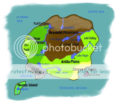
The Isle of Andvari is a small island, with an approximate area of 550 square miles, located on the northern hemisphere of an unknown planet. The top fourth of the island is covered completely in ice during the winter months, the frozen landscape making it an inhospitable and even treacherous place during the cold season.
To the northwest is the Norna Sea and to the northeast is the Gests Sea, both of which have extremely cold waters all year round and even freezing over at certain points during the winter. To the south, encompassing a little under half of the island’s perimeter is the Volsung Ocean, thought to be the largest body of water on the planet.
Brynhild MountainsThis mountain range covers nearly a third of the land mass of Andvari, stretching across the entire northern region and narrowing down the center of the island before disappearing in a small tail a few miles above the southern shores. The peaks are highest near the middle of the range, forming a descending ‘T’ if seen from an aerial view. The northern rim stops directly at the sea, where the cliffs grow steadily lower and flatter towards the east and west ends.
During the winter, and even a cold fall month, the top half of the range is covered completely in ice and snow. Blizzards are a common occurrence during this time, so few dare to venture into these treacherous areas as not many have ever been seen again. But come spring, the meadows and fields found in the lower altitudes can be found in bloom from frequent rain, and the temperature rises to tolerable levels in the summer.
Gram’s PeakThe highest point on the island, Gram’s Peak is essentially part of the Brynhild Mountains and located at the exact center of the island. Its height has never been measured, but rumors say that if you can reach the top of the peak, you’ll be able to see the entire island around you and even the seas that touch the shores. But such a expedition is extremely risky, for many have tried and few if any have lived to tell of the treasures that embellish the peak. At the top of Gram’s Peak is something called the Light of Andvari, named for the seemingly eternal light that shines all around as a guiding beacon for any lost travelers on the island, or even at sea. It is assumed that the light is merely a reflection of the sun during the day and the moon at night, for the only time the light disappears is during an Eclipse or a New Moon.
Ridill’s CaveA series of caves found at the base of the northwestern tail of the Brynhild Mountains, these caves can only be accessed during late spring and summer through early autumn when the ice thaws from the entrance of the caves. The tunnels lead through the caves like a maze and few have found anything of interest in the caverns, and some have even failed to find the way back out.
Lake SinfjotliThe northernmost lake on the island, Sinfjotli is in the middle of the northern range of the Brynhild Mountains, and like the rest of the northern mass, the lake is frozen over with a few meters of solid ice during winter. A small river dubbed the Sinfjotli River runs a couple of miles northward from the lake, eventually reaching the northern rim of the island where the Norna Sea meets the Gests Sea.
Lake SigurdOne of the larger lakes, Brynhild is located a few miles directly north of Gram’s Peak. It then travels northeast as the River Sigurd to merge with the Helgi River just a mile before the larger lake.
Lake HelgiA small and slender lake in the northeast of the island that sits between the Attila Plains and the Brynhild Mountains, Helgi is the third northernmost lake on the island but does not freeze over in the winter like Sinfjotli and Signy. It has a river known as the Helgi River that runs north and divides the mountains from the plains, encircling the upper half of the northern valley of the Regin Plains before opening to the Gests Sea.
Hreidmar ForestCovering a little less than a fourth of the island’s surface area, the forest stretches down from the northwestern rim of the island and extends over most of the southwestern area of island from there. Most of the trees are tall evergreens, although there are seasonal plants in the north.
Most of the northern third of the forest, from the horizontal run of the Sigmund River and up, is stripped bare and becomes coated with snow during the winter and most animals migrate out of the area during the cold season. But the rest of the forest remains thick and green all year round, extremely hot and humid during the summer in the southern region.
Otr FieldA small area of green pastures on the western shore of the island and surrounded on the other three sides by the Hreidmar Forest, the field is a little over six miles in diameter. The field is located just south of the Sigmund River, which is also the source of the many springs and ponds that are found in the region. The grass is fresh and green during the warmer months, blooming with a variety of flowers in the spring. But in the fall, the flowers wither and the grass dries into tanned stalks in the winter.
Lake SignyThe smallest lake on the island, it is the second northernmost body of large water and also freezes over during the winter but not as thickly as Lake Sinfjotli. Lake Signy is located at the northeast inner corner of the Brynhild Mountains, with the small River Signy traveling southward down the eastern edge of the mountain range before merging with the Sigmund River.
Lake SigmundOne of the largest lakes on the island, Lake Sigmund is located slightly southwest of Gram’s Peak at the edge of the Brynhild Mountains, and also leads into the Sigmund River that travels north. Like its lake source and the River Signy, the Sigmund River divides the eastern edge of the Sigurd Mountains from the western border of the Hreidmar Forest, before meeting the River Signy and pivoting west to end where the Norna Sea meets the Volsung Ocean.
Attila PlainsOver a fourth of the island’s surface area consists of a variety of grasslands that stretch from the northeastern rim and extend down the edge of the Brynhild Mountains to cover most of the southeastern region of the island. Aside from the northernmost part of the plains, the rest of Attila is prairies and savannas where the southernmost inland areas become increasingly hot and dry during the summer.
Loki ValleyThe northernmost range of the plains, known as the Loki Valley, is slightly enclosed by a small trail of the Brynhild Mountains. The valley is situated directly south of the Helgi River and north of a small part of the Regin River, but the region is not far north enough to see ice or snow during the winter. The grass is fairly green throughout most of the year, only withering during the coldest month of winter.
Shore of AegisA small area on the southeast shore of the island, it is the only part of the southeastern region not encompassed by the Attila Plains. The shore is a sandy beach that stretches for nearly seven miles in a semicircular shape, encircling over half of a small bay that pushes a mile into the island. The bay is the only place on the island that contains warm waters, even during the winter, and likewise the beach has is the only shore on the island with soft warm sand.
Hrotti’s CoveA strange U-shaped rocky land mass in the middle of the bay, the small cove points inward towards the Shore of Aegis and is about a mile away from the main island’s shore on all sides. During low tide, the top of a cave entrance can be seen inside the U of the cove, but rumors say that the inner caverns are extremely low and the tunnels are so much of a maze that exploring the cave is impossible. Not much else is of interest at the cove for its moss-covered rocky surface is either too slippery or sharp for comfort.
Lake ReginThe largest lake on the island several miles southwest of Lake Sigurd and directly southeast of Gram’s Peak, Lake Regin also separates the Attila Plains from the Brynhild Mountains. The lake has a river that runs almost straight north at a slight eastern angle before turning sharply to travel southeast for two miles mile and then straight east to meet the Gests Sea. Known as the Regin River, it closes off the Loki Valley from the rest of the Attila Plains.
Lake GunnarOne of the smaller lakes on the island, Lake Gunnar is situated right in the middle of the southern region of the Attila Plains, a few miles southeast of Lake Regin. But strangely enough, the lack of rains in this area during the summer causes the lake and its River Gunnar to nearly dry up in the hot season. Its accompanying river slows to a small stream at this time, flowing westbound until it merges with the much larger Gudrun River.
Lake GudrunA murky lake at the edge of where the Attila Plains and the Hreidmar Forest meets the Dead Lands, the water here is thought to be polluted because of its black and thick quality. But oddly enough, its Gudrun River becomes cleaner as it leaves the lake, turning completely clear by the time it merges with the River Gunnar halfway through its trek to the Volsung Ocean. The Gudrun River acts as that which separates the Attila Plains from the Dead Lands.
Dead LandsAs its name suggests, few if any have survived after trekking through the dark and treacherous Dead Lands. Essentially “no man’s territory,” no life exists in this region as the earth has been blackened and the area smells of rot. The exact reason behind the inability to live is unknown, though pollution from an unidentified source is thought to be the cause.
Edda StraitThe part of the Volsung Ocean that separates the main Isle of Andvari, namely the Dead Lands, from Niveus Island is known as the Edda Strait. The waters here are extremely unpredictable with many undertows and even a few whirlpools near the mainland. The waves are calm and cool around Niveus Island, but it’s the swim there that’s perilously impossible.
Niveus IslandA small mysterious island a few miles off the southwestern coast of the main Isle of Andvari, Craftmakers are the only ones who have ventured onto this islet because it is located right off the shore of the Dead Lands. The island is thought to be approximately 35 square miles, and is the native home of Chupins and Serpins.
Lake AquilusThe small and only lake on Niveus Island, Lake Aquilus is a fresh spring water lake that acts as a main source of water for the life on the small island. But like its island, little else is known about the lake.


